Tree Cover Data Sets on Global Forest Watch, Explained
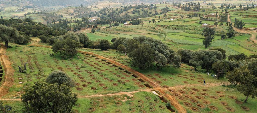
Trees outside of dense forests in Ethiopia
The emergence of new Earth observation data has radically improved our ability to map tree cover, while automated methods and lower computing costs have accelerated the production of data sets to inform our understanding of the global distribution of trees. Global Forest Watch (GFW) hosts three tree cover data sets, including World Resources Institute’s (WRI) newly updated Tropical Tree Cover data (formerly called Trees in Mosaic Landscapes).
These data sets vary in geographic and temporal coverage, resolution, how they define tree cover and other characteristics that can make each best suited for different use cases. Here, we explain these differences and how all three data sets provide valuable information on the extent of forests across the tropics and around the globe.
What tree cover data sets are available on GFW?
Data Set | Source | Geographic Coverage | Spatial Resolution | Years of Coverage | Variable | Tree Definition | |
Height criteria | Canopy Criteria | ||||||
Tree Canopy Cover | Global | 30m | 2000, 2010 | Tree cover (%) | All vegetation ≥5m in height. | n/a | |
Tree Cover Height | Global | 30m | 2000, 2020 | Tree height (m) | Woody vegetation ≥3m in height | 20-25% | |
Tropical Tree Cover* | Tropics | 10m | 2020 | Tree extent | Woody vegetation ≥5m in height, or ≥3m in height with canopy requirement. | Woody vegetation 3-5m in height must have a ≥5m crown diameter. | |
* This data set is available as tree extent at 10 m resolution or tree cover percent at 0.5 ha resolution
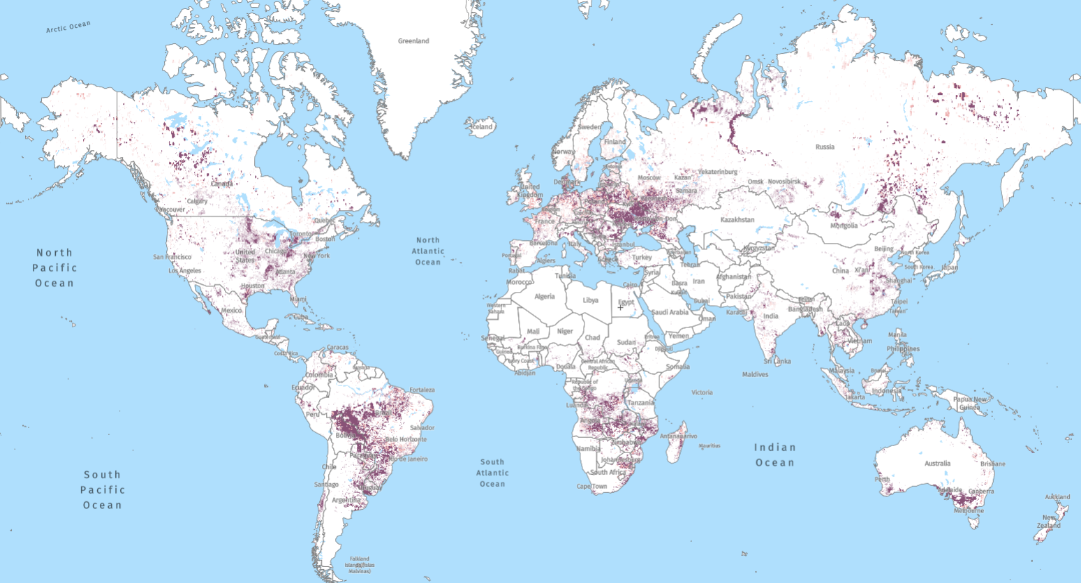
Tree Canopy Cover
In 2013, experts at the University of Maryland’s (UMD) GLAD Lab published the Tree Canopy Cover data set, which maps tree canopy cover across the globe at a 30-meter resolution and is available on GFW for the years 2000 and 2010. This data set was among the first efforts to map tree cover at a global scale using medium resolution imagery. Furthermore, it established a baseline for the annual tree cover loss data; these data sets together served as the basis for the launch of Global Forest Watch in 2014.
The Tree Canopy Cover layer estimates percent tree cover, which measures the density of tree canopy cover within a 30-meter pixel. The data set defines trees as all vegetation of at least five meters in height and is derived from Landsat imagery.
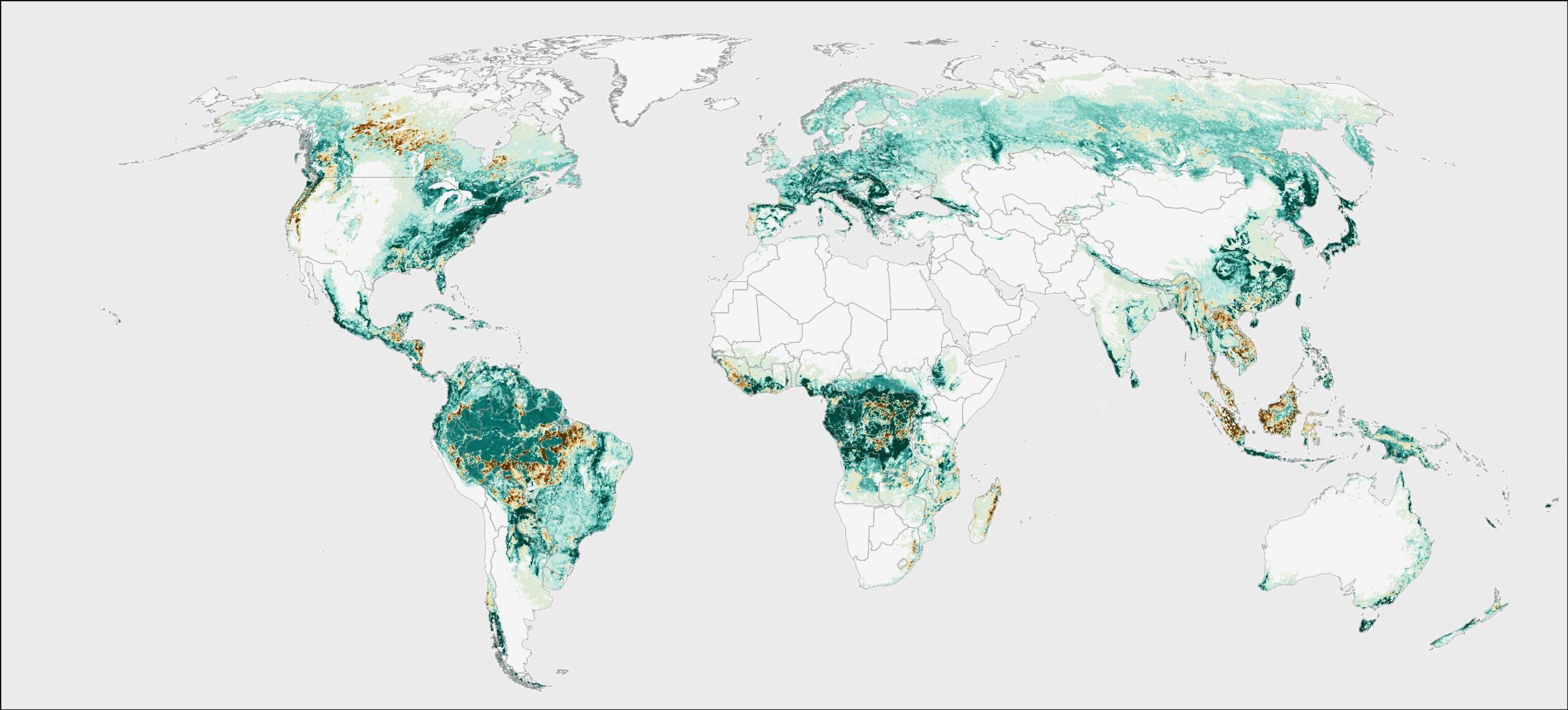
Tree Cover Height
In 2021, experts at the UMD’s GLAD Lab published the Tree Cover Height data set, which maps tree cover height across the globe at a 30-meter resolution and is available on GFW for the years 2000 and 2020. This data set allows for improved detection of tree cover gain and serves as the basis for the 20-year net change data on GFW. Unlike tree canopy cover, which reaches its maximum soon after tree growth begins, tree height changes gradually and is linearly related to forest biomass and carbon storage.
The Tree Cover Height layer estimates tree canopy height, which refers to the height of the tree canopy in meters within a 30-meter pixel. The data set defines trees as woody vegetation of at least three meters in height and is derived from Global Ecosystem Dynamics Investigation (GEDI) LiDAR measurements and Landsat imagery. This data set estimates the 95th percentile of tree canopy height, and accordingly will represent the upper bounds of height for pixels with fractional tree cover, or pixels with variable canopy height.
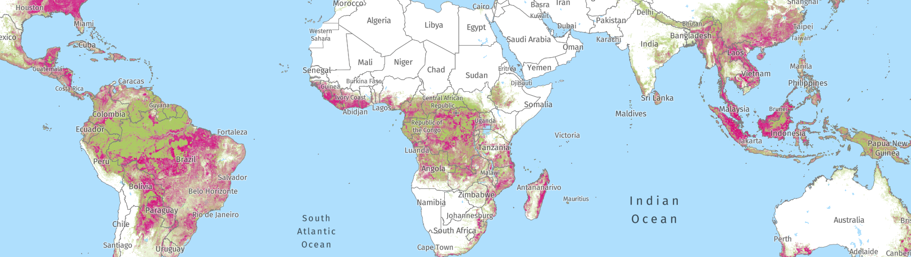
Tropical Tree Cover
This year, WRI updated the Tropical Tree Cover data set (now available for download), which maps tree cover across the tropics at a 10-meter resolution and is available on GFW for the year 2020. Unlike the other data sets, the Tropical Tree Cover data set is based on imagery from Sentinel satellites, which increased the resolution of freely available remote sensing data to 10 meters when launched in 2015. This data set capitalized on the advancement in resolution to improve tree cover detection in non-forested areas, especially in drylands, urban areas and on cropland, and our ability to monitor trees at small spatial (local) scales.
The Tropical Tree Cover estimates tree extent, which refers to the probability that one or more tree canopies intersect the middle point of a 10-meter pixel (on GFW, we display the tree extent data with a probability threshold of 40%). “Percent tree cover” is derived by averaging tree extent probabilities at a half-hectare scale. Both the 10-meter and the half-hectare versions of the Tropical Tree Cover data set are available to users on GFW. The Tropical Tree Cover data set defines trees as woody vegetation greater than five meters in height, or between three to five meters with a minimum canopy diameter of five meters. The data is derived from Sentinel 1 and Sentinel 2 imagery. Visit the Help Center to learn more about Tropical Tree Cover.
How do these data sets differ and what does this mean in practice?
Differences in Spatial Resolution
The Tropical Tree Cover data set has a higher spatial resolution at 10-meters, while both the Tree Canopy Cover and Tree Cover Height data sets are 30-meter resolution. At 30-meter resolution, it can be difficult to differentiate small patches of trees, making the Tropical Tree Cover data set more appropriate for monitoring tree cover in areas with disperse tree cover, including dryland regions such as the Sahel, forest perimeters and riparian zones, as well as natural trees in agricultural and urban areas. These differences in resolution will result in different estimates of tree cover in an area of interest since trees that are undetected at 30-meter resolution may be identified in at 10-meter resolution.
Tree cover detection at 10 and 30-meter resolution
Differences in Temporal and Geographic Coverage
A key difference between the three data sets is their annual availability and geographic coverage. The Tree Canopy Cover data set is available for the years 2000 and 2010. The Tree Cover Height data set, originally produced for the year 2019, is now updated and available on GFW for the years 2000 and 2020. The Tropical Tree Cover data set is currently limited to the year 2020. Given the longer historical availability of the Landsat archive, users may wish to prioritize historical record (Tree Canopy Cover and Tree Cover Height) over resolution (Tropical Tree Cover).
For geographic scope, the Tropical Tree Cover data set only covers the tropics, while the Tree Cover Height and Tree Canopy Cover data sets have global coverage. Therefore, the Tree Cover Height and Tree Canopy Cover data sets should be used for applications in temperate and boreal forests, while the Tropical Tree Cover data set provides a higher resolution look at tropical forests.
Differences in Change Data
The Tree Canopy Cover and Tree Cover Height data sets are used as the basis of GFW’s forest change data sets since they are available for multiple years.
The Tree Canopy Cover data for the year 2000 can be used as the baseline for GFW’s annual tree cover loss data — tree cover loss is calculated for various tree canopy density thresholds in the year 2000 to meet definitions of forest that vary by tree canopy density. GFW presents tree cover loss statistics and maps based on a minimum canopy density of 30% in the year 2000, but users can modify that threshold to best suit their purposes. The Tree Cover Height data serves as the baseline for the 20-year tree cover gain and net change data sets available on GFW.
Currently, Tropical Tree Cover is a static map for 2020 and cannot be used to directly assess change, but WRI is planning to release an annual Tropical Tree Cover product on GFW in the future.
Users whose primary interest is measuring tree cover change should use the baseline data set associated with the relevant forest change product to avoid any mismatches in definitions and methods.
Differences in Tree Definitions
While the Tree Canopy Cover and Tree Cover Height data sets are based on minimum height criteria, the Tropical Tree Cover data set has a variable height requirement of three to five meters based on canopy diameter. This means that the Tropical Tree Cover data set excludes tall herbaceous vegetation such as sugarcane, bananas and cacti that are considered trees in the other data sets.
For users who are measuring tree cover in areas with large presence of these crops, the area of tree cover detected by the three data sets will differ greatly. It is important to note that the Tree Canopy Cover and Tree Cover Height data sets do not measure forest area using the same criteria as National Forest Inventories or the Food and Agriculture Organization’s Forest Resource Assessment (FRA). Read our blog to learn more about how the FRA measures forest versus how GFW measures tree cover, and about other differences in purpose, scope and approach between these data sets.
Which data set should I use for my specific application?
How will these data sets be updated in the future?
Moving forward, UMD will publish annual integrated tree canopy structure data sets that will enable users to assess annual changes in canopy height and cover.
WRI is currently developing annual Tropical Tree Cover data for 2017-2022, which will allow users to analyze tree cover change across the tropics at the 10-meter scale. WRI is also working on additional pilot projects to improve detection of tree crops and derive carbon estimations for small scale restoration projects.
The composition, height and density of forests vary widely from place to place. Depending on the area, timeframe and specific forest type, different tree cover data sets may be better suited to meet your goal. Remote sensing data can help us monitor a variety of forest attributes using new advances in satellite technology and processing methodologies. This results in a variety of data sets that can complement each other in informing our understanding of the global distribution of trees and provide unique opportunities to support restoration and deforestation monitoring.
To stay up to date on the latest Tropical Tree Cover news, please register for the Global Forest Watch mailing list and select your interest in Landscape Restoration.