Technical Blog: Indonesia Tree Cover Loss and National Deforestation Data Explained
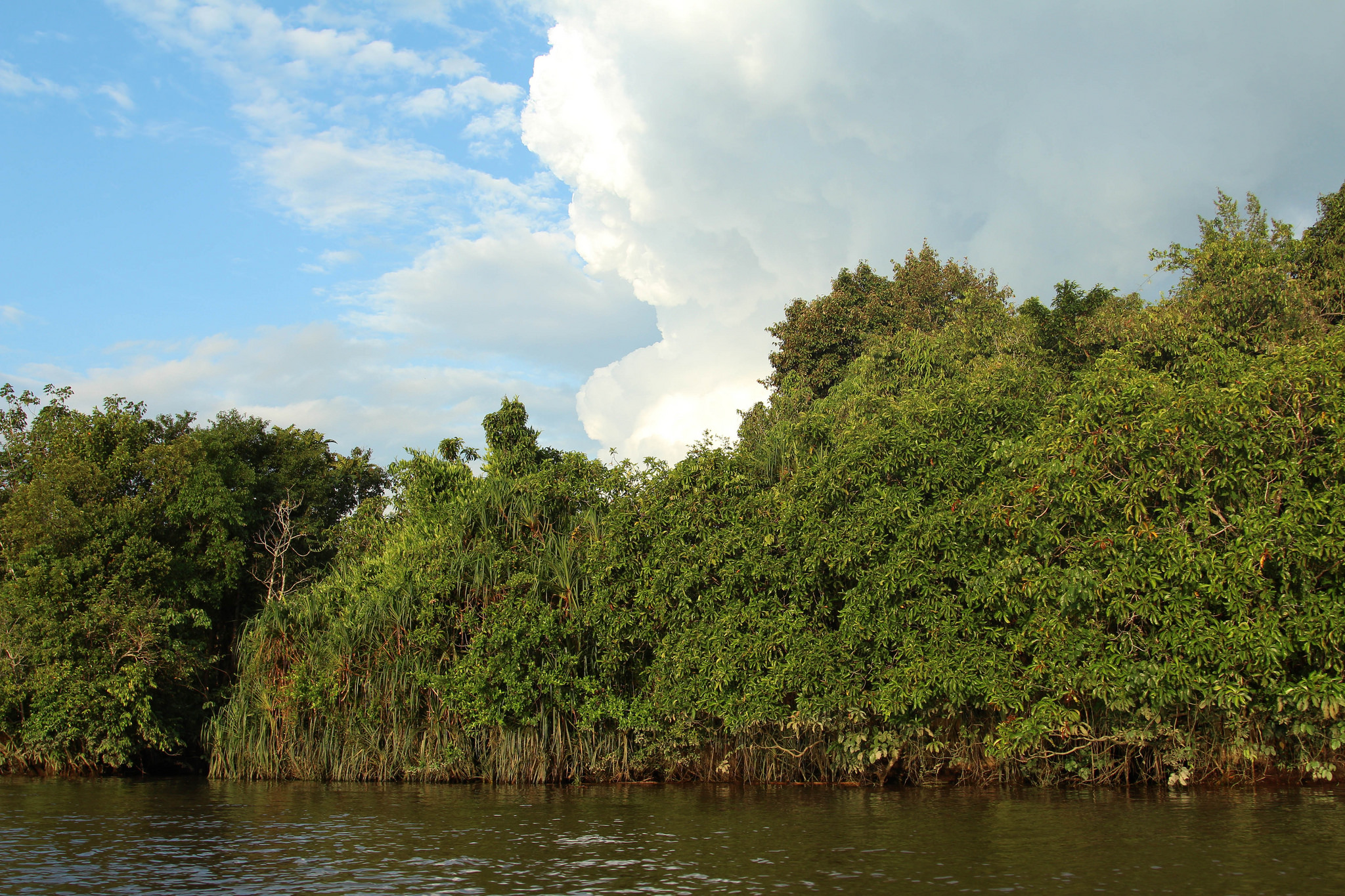
Peat Swamp forests in Central Kalimantan. By: WRI/Flickr.
According to data from the University of Maryland (UMD), available on Global Forest Watch, tropical tree cover loss in 2017 was the second worst on record. Contrary to the global trend, both the UMD data and the official deforestation data provided by the Ministry of Environment and Forestry (MoEF) show that Indonesia actually experienced a decline in tree cover loss compared to the previous year. While the trend in these two datasets is similar, the amount of loss varies between the two sources. In this blog, we shed light on the differences between the UMD tree cover loss data and Indonesia’s national deforestation data.
What does the UMD data show?
According to the UMD data, Indonesia had 1.3 million hectares of tree cover loss in 2017. Viewing the total loss in Indonesia enables comparisons among the rest of the world, but given the high density of planted forests, it may not be best suited to provide an in-depth look at the Indonesia’s forest change. However, there are several different ways to look at the UMD tree cover loss in Indonesia to offer more perspective.
We can look at the amount of loss in natural forests (i.e. excluding loss in plantations mapped in 2013/2014) to get a better sense of how forests are changing in the country. By that metric, UMD’s data shows Indonesia had 1.0 million hectares of natural forest loss in 2017.
To look at loss in the most important forests, we can also filter the data to only show change inside primary forest (as defined by Margono et al.). UMD’s data shows Indonesia had 0.4 million hectares of primary forest loss in 2017.
The MoEF reported 0.5 million hectares of forest loss in 2017 using separate criteria to designate loss within primary forests, secondary forests and Acacia plantations.
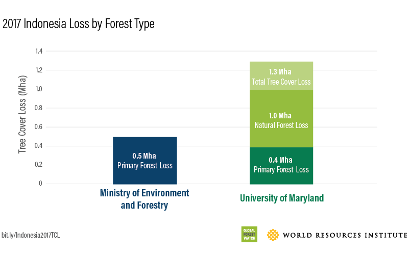 Figure 1: Comparison of 2017 MoEF forest loss and UMD tree cover loss by forest type.
Why do the numbers differ?
1. Methods for analyzing loss: UMD’s measure of tree cover loss uses the removal of at least half of tree cover within a 30-meter pixel (also known as stand replacement disturbance). This loss may be the result of human activities, including forestry practices such as timber harvesting or deforestation (the conversion of natural forest to other land uses), as well as natural causes such as disease or storm damage. Fire is another widespread cause of tree cover loss and can be either natural or human-induced.
In contrast, MoEF defines deforestation as loss occurring within seven classes of forest as derived from the MoEF’s land cover map. The land-cover map is produced using visual interpretation of Landsat satellite images at a mapping unit of 6.25 hectares.
The MoEF reports gross loss numbers each year, acknowledging forest gain within timber plantations after the trees are mature (usually within 5 to 7 years). In contrast, UMD’s tree cover loss data does not include any tree cover gain.
2. Year of tree cover loss detection: UMD data is dependent on satellite images and defines one year of data by the calendar year (January to December). Persistent cloud cover within satellite imagery can interfere with the immediate detection of change on the ground, which can sometimes lead to detection of tree cover loss the year after it occurred. As most fires happen late in the calendar year, UMD may not get a clear satellite image to detect the fire until early the following year.
MoEF defines one year of data by July of the previous year through June of the stated year, and therefore does not experience this lag in detection.
3. Definitions of forest extent: UMD defines forest extent as the biophysical measurement of tree cover greater than 30 percent in the year 2000. With this biophysical measurement, the extent is much larger than the primary forest extent as defined by the MoEF (1.61 million hectares as opposed to 105 million hectares). However, when UMD tree cover loss is filtered using MoEF’s definition of forest extent, UMD’s 2017 loss equates to 0.4 million hectares – a similar to the 0.5 million hectares reported by the MoEF.
| Tree Cover Loss (Hansen/UMD/Google/USGS/NASA) | Deforestation (Indonesian Ministry of Environment & Forestry) |
| Area Includes: Tree cover: woody vegetation greater than 5 meters in height, with greater than 30% canopy cover Natural forest: all areas of tree cover excluding mapped plantations Primary forest: areas of tree cover that overlap with 2000 intact and degraded primary forest extent (as defined by Margono et al.) | Area Includes: Land area of more than 6.25 hectares with trees higher than 5 meters at maturity and a canopy cover of more than 30 percent Forest: includes the following seven land cover classes: Primary dry land, mangrove and swamp forest, Secondary dry land, mangrove and swamp forest, industrial plantation forest (pulp and paper plantation) |
| Loss Defined As: The removal or mortality of tree cover due to a variety of factors, including mechanical harvesting, fire, disease, or storm damage. As such, “loss” does not equate to deforestation | Loss Defined As: The observed changes of seven forest land cover classes change into non-forest classes (e.g. shrub, plantation) |
| Area Observed: Includes shrubs, rubber and palm trees in addition to natural forests | Area Observed: Rubber and oil palm trees not counted, timber plantations are counted |
| Supervised learning algorithm method | Visual (manual digitization) method |
Minimum Mapping Unit: 0.09 ha (30 x 30 m) | Minimum Mapping Unit: 6.25 ha (250 x 250 m) |
| Observation Period: January – December | Observation Period: July – June |
| Gross Deforestation | Net (loss – gain) Deforestation |
Loss not reported by MoEF may be occurring younger forests or forests that were degraded during the past 30 years (and thus not included in the primary forest data), but in some cases is still relevant to deforestation statistics. By using both MoEF and UMD data we can capture a more complete picture of tree cover change in Indonesia.
Despite definitional, detection and scale differences, both the MoEF and UMD data sets capture important types of loss and show similar trends.
