Putting People on the Map: the Land Tenure Data Challenge and Global Forest Watch
By Rachael Petersen and Caleb Stevens Satellites provide a wealth of information about our planet’s resources. NASA’s Landsat satellite, for example, produces images that can be analyzed by complex algorithms to calculate areas of forest loss with greater precision than ever before. These advances allow Global Forest Watch to create an unprecedented picture of how forests are changing around the world. But our picture is incomplete – the people are missing. Pixels of data produced by distant satellites fail to tell key pieces of the story: who lives in, uses, and manages the world’s forests. Satellite images do not reveal where governments have granted concessions for companies to use forest land for logging, mining or agriculture. Nor do they indicate where indigenous peoples or local communities have customary rights over the forest. Without this additional information we cannot determine where land claims contradict each other, and how land conflict impacts forest management and local people. This is why Global Forest Watch is committed to putting land rights literally “on the map” by visualizing land tenure data on our platform. However, Global Forest Watch faces a number of challenges in gathering, visualizing and making public this information. This blog post explores the barriers to acquiring accurate maps of land rights, and describes the path forward for Global Forest Watch to include critical information about people.
Better Land Tenure, Better Forest Management
More than one billion people depend on forests for their livelihoods. As of 2013, approximately 30 percent of the world’s forests are owned or controlled by indigenous peoples or local communities, making them critical stakeholders managing forests. But despite evidence that local communities can successfully manage and conserve forests, governments still control the majority of forest lands — over 73 percent of global forest area. Meanwhile, as industrial agriculture expands, competition for access to land between industry, governments, and communities grows, putting pressure on forests and threatening local peoples’ livelihoods. Without statutory (formal) recognition and protection of their land rights, communities lack legal recourse following infringement of those rights. Nor can they receive incentives to invest in the future productivity of the land, or benefits from payment for ecosystem services programs that support conservation (e.g., REDD+). Amid this pressure, secure and legally-recognized land and resource tenure is a necessary ingredient for sustainable community-based forestry. Communities are not the only actors impacted by land rights. Companies can incur increased operating costs due to social unrest around land conflict. Investors face reputational risks in areas with overlapping land allocation. In fact, research shows that 31 percent of all commercial concessions for mining, logging and so on (by area) overlap in some way with community and indigenous territories, threatening billions of dollars of investment. The human costs are exemplified by a recent clash between indigenous peoples and oil palm developers in Sumatra, which left one person dead. While we lack systematic data on killings related to land and forest conflict, recent investigations suggest that such confrontations have increased in the last decade. Areas where large populations depend on land or forests for their livelihoods are particularly prone to violent conflict related to land rights. Due to public pressure, many companies are now committing to standards that protect not just trees, but also people. For example, Wilmar, L’Oreal, Mars, and Kellogg are just a few of the major brands or trading companies to adopt new policies that require “free, prior and informed consent” of local communities impacted by their suppliers’ oil palm plantations.
The Land Tenure Data Gap
By incorporating land tenure information, Global Forest Watch will be among the first global tools that enable stakeholders to better understand who to hold accountable for forest loss, and who to recognize and reward for forest protection. However, collecting geospatial data on local land rights is challenging for several reasons. In many countries, community land remains largely undocumented. Official demarcation of lands and resource rights is costly, timely, and contentious. Governments lack the will or capacity to carry out field mapping to build national inventories of community land. As a result, comprehensive national maps of local land rights are rare. More commonly, incomplete land tenure data sets are scattered across sources and are difficult to synthesize. Often information exists on paper only, rather than in geo-referenced digital formats that can be easily shared, displayed, updated and analyzed online. Fortunately, many initiatives are tackling the land tenure data challenge. Local groups are filling the information gap using participatory community mapping. For example, the Indonesian national indigenous group, AMAN (Aliansi Masyarakat Adat Nusantara), declared its intention to map 30 million hectares of indigenous forest land by 2020. Through a variety of approaches, the following initiatives aim to make land and resource rights information more accurate and accessible:
- Global Map of Indigenous and Local Community Lands – WRI’s Land and Resource Rights Initiative is collaborating with several organizations from around the world to create a global, online map of community and indigenous land rights.
- WRI Rights to Resources Map – an interactive map indicating the status of local natural resource rights in national laws of sub-Saharan African countries
- Focus on Land in Africa (FOLA) – a partnership that explores how land rights affect – and are affected by – development in Africa.
- Mapping for Rights (Rainforest Foundation UK) – an online platform to help guarantee access to accurate geographical information about the presence, land use and rights of indigenous peoples and communities in the Congo Basin.
- Land Portal (the International Land Coalition) – an easy-access platform to share land related information, to monitor trends, and identify information gaps to promote effective and sustainable land governance.
- OpenTitle (Thomson Reuters) – helps rural communities in developing countries boost economic development with a land registration system that can handle growth.
- Country- and regional-focused mapping platforms, including RAISG in the Amazon Basin, AMAN in Indonesia, Open Development Cambodia, and the Sarawak Geoportal in Malaysia.
The vision and the future: land rights transparency
Global Forest Watch is working collaboratively with other groups to visualize land tenure data under the “People” tab of our interactive online system. Users will soon be able to easily overlay tenure information with forest change and other forest use data for many countries. We also hope to include detailed country-level land tenure information within our country pages. These data will help users understand the effectiveness of communities in protecting forests, and identify areas with unclear land allocations and tenure.
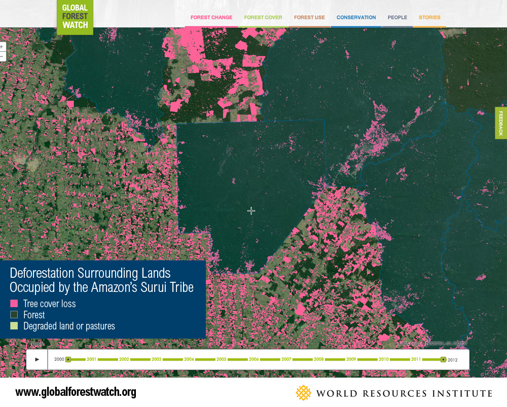 The Surui tribe of the Brazilian Amazon is fighting to protect their territory – called the Sete de Setembro – from illegal logging. Global Forest Watch shows how forest loss encircles the boundaries of the territory.
 Communities can also use GFW to quickly “raise the alarm” and alert the world to illegal incursions into their forest lands. They can use the platform as a low-cost solution to land monitoring, reducing the need for patrols on the ground. With Global Forest Watch, we now have accurate, reliable, up-to-date information on how forests are changing around the world. The time has come for a similarly transparent picture of land tenure. We can no longer afford to have so little information about which forests are claimed by whom, and under what conditions. This information is critical to achieving sustainable forest outcomes, and strengthening the rights of indigenous peoples and local communities who depend on the forest for their livelihoods and cultural identity. Help improve Global Forest Watch. Do you know of existing data sets that would strengthen our platform? Contact us here.