- Data & Tools
Technical Blog: Comparing GFW’s 2017 tree cover loss data to official estimates in Brazil
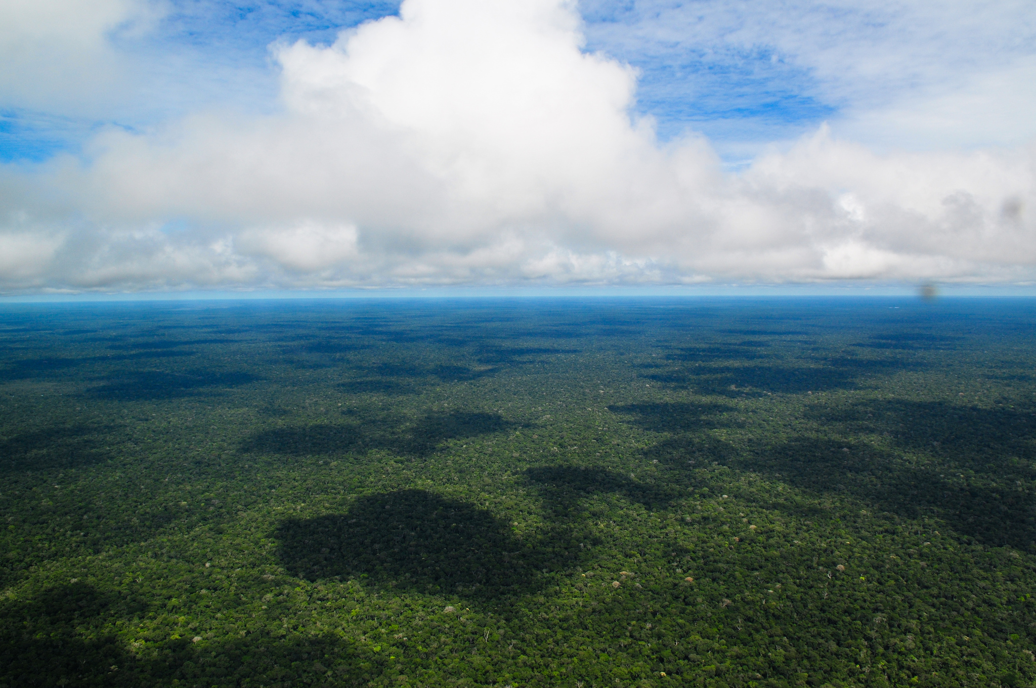
New data on global tree cover loss shows a sustained record high in Brazil. At first glance, the University of Maryland data released on Global Forest Watch can seem to tell a different story than official national estimates. PRODES, the official Brazilian government forest monitoring system, reported 0.69 million hectares of loss in the Brazilian Legal Amazon in 2017, significantly less loss than the 3.47 million hectares of loss found in the 2017 University of Maryland data. But a closer examination of each dataset reveals the results are actually very much aligned, just measuring two different but important types of change in forests.
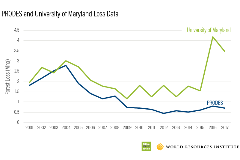
In the past, we have speculated that this difference is due to the methodologies of the two monitoring systems. The University of Maryland data captures loss from a larger forest area than PRODES including loss in secondary forest, forest degradation from fire, and loss as small as 0.1 hectares. It also uses January to December to capture loss, while PRODES uses August to July.
This year we replicated the PRODES methodology using the University of Maryland data to see whether methodological differences could in fact explain the discrepancies. The PRODES data only captures new, clear-cut deforestation of primary forest, meaning when a forest is disturbed, it is no longer included in PRODES monitoring even if it remains forest. To account for this, we filtered the University of Maryland data to count only loss that occurred within PRODES 2017 primary forest extent, which removed 46 percent of loss. PRODES also only includes areas of loss greater than 6.25 hectares, so we also removed loss less than this size, which removed another 13 percent of loss. The result of implementing these two steps to align the measurements was 1.41 million hectares of tree cover loss.
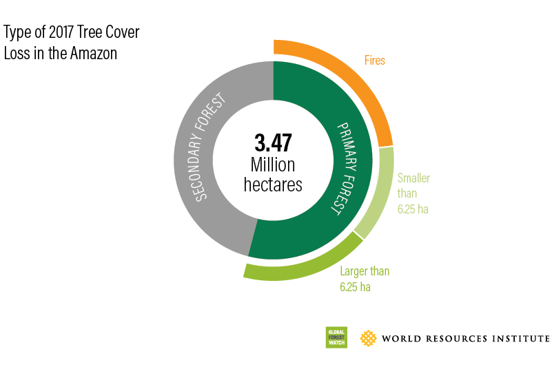
We suspected that much of the remaining difference came from the exclusion of fires in the PRODES data, so we also removed tree cover loss due to fire, which the University of Maryland mapped for the first time this year. This exclusion brought the University of Maryland data to 0.61 million hectares of tree cover loss in the Amazon, compared to 0.69 million hectares for PRODES. The remaining 11 percent difference is likely due to the different time periods of the datasets, or small speckles of loss that PRODES may have captured around larger patches of loss, but was not included in our filtering methodology. Our size filter only includes pixels that touch an area of loss larger than 6.25 hectares, meaning pixels that were very close, but not touching larger areas, were excluded.
These results help confirm that the differences reported between the two monitoring products are likely due to definitional differences – the University of Maryland data includes degradation from fires and smaller loss areas, and captures loss in a larger forest area than PRODES. With these differences in mind, we can draw several conclusions about the state of forests in the Brazilian Amazon. PRODES results demonstrate that while the battle is far from over, Brazil has had impressive results in reducing the deforestation of primary forest since the early 2000s. The University of Maryland data shows an increase in other tree cover losses, indicating new battles to be fought for the ecological integrity of the Amazon.
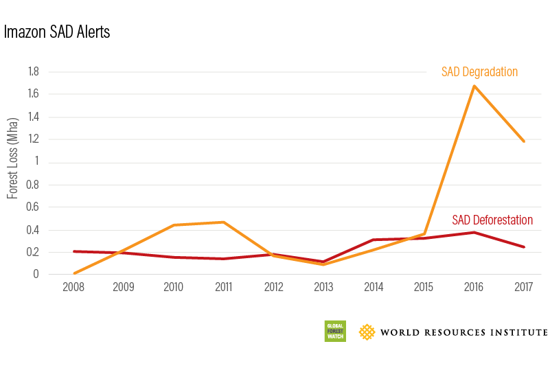
One important caveat to the increase in tree cover loss is that the University of Maryland method changed slightly in 2011, to better detect fires. This means that the fire seasons of 2005 and 2010 may be less well represented in the data. Nonetheless, other monitoring systems confirm the increase in degradation detected by the University of Maryland data. The Brazilian NGO Imazon looks at changes in degradation and deforestation through their SAD alerts, and finds an upward trend in degradation in 2016 and 2017.
While the additional changes captured by the University of Maryland data may not be caused by clear-cutting of pristine forests, the loss still has an impact on ecosystem services, biodiversity, and climate. Studies show that degradation from fire is now counteracting the reduction in emissions from reducing deforestation in Brazil. Thus, both PRODES and the University of Maryland data have a critical role in monitoring one of the most important forests in the world.
